Would you like to make this site your homepage? It's fast and easy...
Yes, Please make this my home page!
Shadow
Re-creations
Objective: Use numerical data to recreate
shadow measurements around the world.
Materials: Chalk, directional
compass, tape measure, globe/atlas/world map
Procedure:
- Using the
compass and a piece of chalk, make a straight chalk line
that points east and west. The line should be about 10
meters long.
- Using the
tape measure and the data from the measurements, draw
each shadow from the east/west line making sure to draw
it in the correct direction (North or South).
- Label all
the shadows with their location name, latitude
measurement, and length of shadow.
Investigative Questions:
- Describe
at least two differences you see between all the shadows
measured.
- Make a
list of all the shadows that point north and another list
of all the shadows that point south.Find all the
locations on a globe, map, or in an atlas. What do the
locations with northern facing shadows have in common?
What do all the locations with southern facing shadows
have in common?
- Find the
two shadows that are closest in length (regardless of
direction).
- Describe
any similarities and differences between these two
locations using your maps.
- Find the
two shadows that are most different in length (regardless
of direction).
- Describe
any similarities and differences between these two
locations using your maps.
- Using the
data, where on the earth would you predict a shadow of 0
cm?
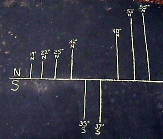
Example of drawing:
BACK
TO SUN SHADOWS ACTIVITIES